


There are no more items in your cart


C-Map DISCOVER AFRICA WEST COAST Marine Chart
R3,430.00
R3,258.50
Tax included
C-Map DISCOVER AFRICA WEST COAST Marine Chart
Cameroon to Delgoa Bay
Includes 1st Year Update Subscription
On Micro sd Card
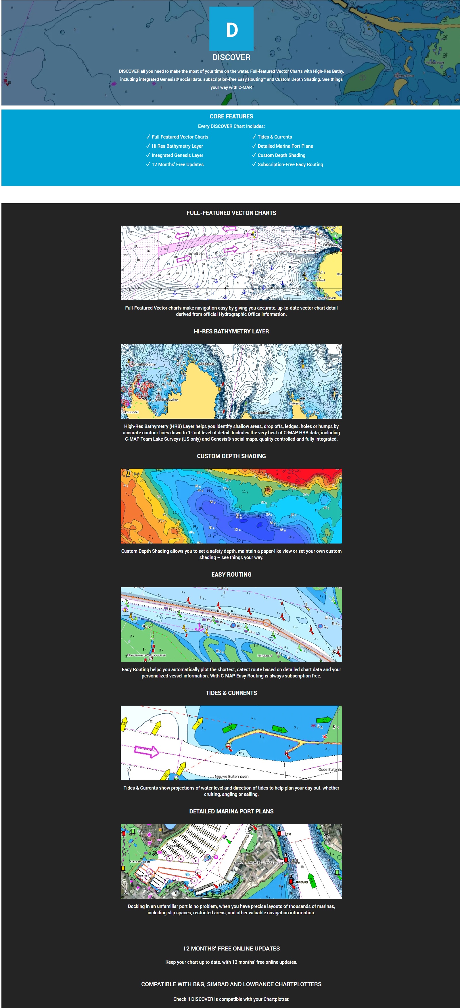
DISCOVER all you need to make the most of your time on the water. Full-featured Vector Charts with High-Res Bathy, including integrated Genesis® social data, subscription-free Easy Routing™ and Custom Depth Shading. See things your way with C-MAP.
C-Map DISCOVER AFRICA WEST COAST Marine Chart
Cameroon to Delgoa Bay
Includes 1st Year Update Subscription
On Micro sd Card
DISCOVER all you need to make the most of your time on the water. Full-featured Vector Charts with High-Res Bathy, including integrated Genesis® social data, subscription-free Easy Routing™ and Custom Depth Shading. See things your way with C-MAP.
Whether cruising, fishing or sailing, C-MAP® DISCOVER™ offers a choice of coverages and includes all of the core features you need to make the most of your time on the water. DISCOVER has the very best of C-MAP High-Res Bathymetry, including integrated Genesis® data, along with full-featured Vector Charts, Custom Depth Shading, Tides & Currents and subscription-free Easy Routing™. Purchase includes 12 months of free online updates. Compatible with Lowrance, Simrad & B&G Chartplotters.
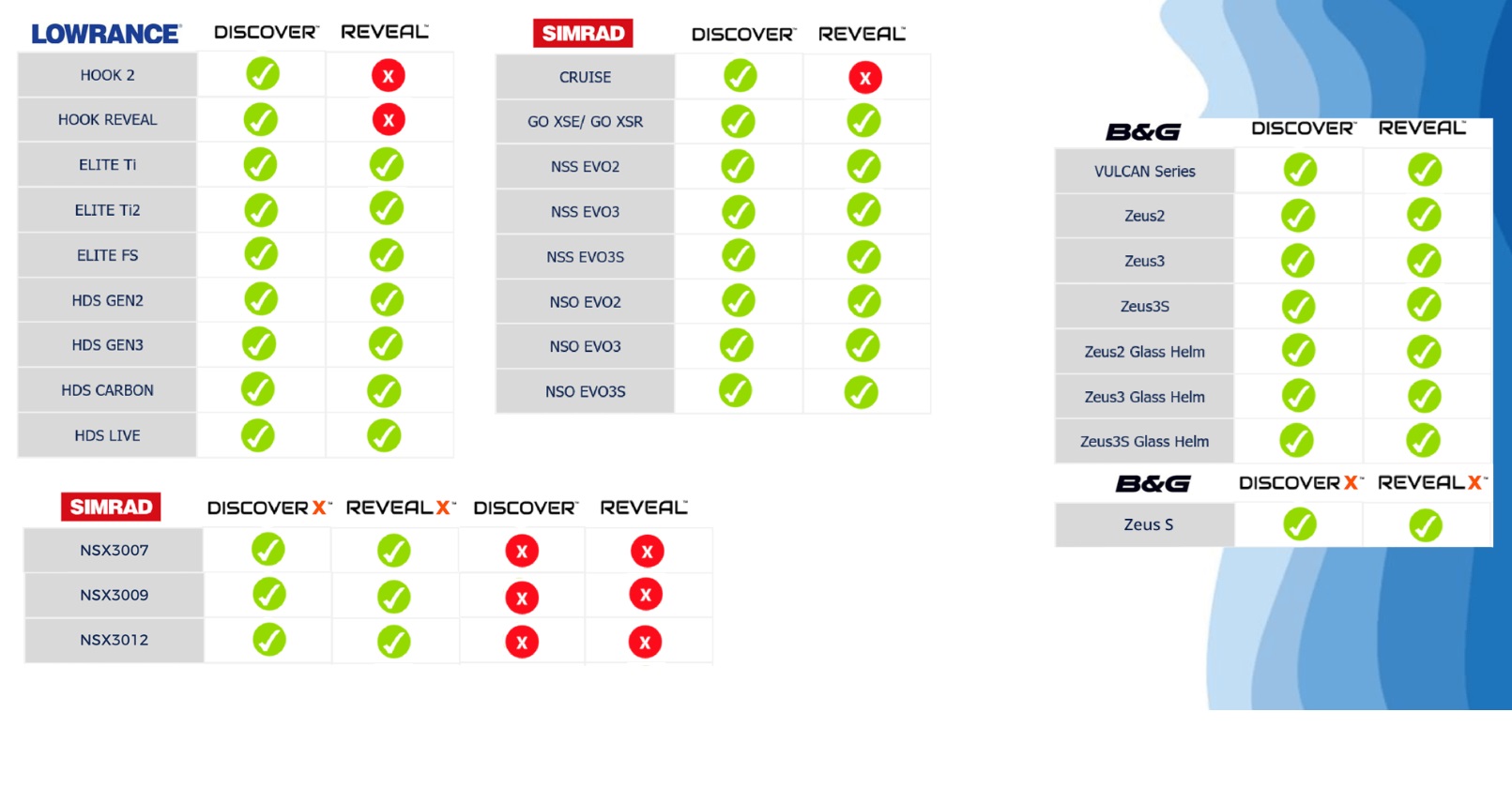
Compatible with HDS Pro, HDS Live, HDS Carbon, HDS Gen 3, Elite FS, Elite TI2 & Elite Ti, Eagle 5-7-9, Hook Reveal or Hook2 5 - 9.
Also Compatable with SIMRAD & B&G Models
Full-Featured Vector Charts – making navigation easy by giving you accurate, up-to-date vector chart detail derived from official Hydrographic Office information
High-Res Bathymetry – HRB layer helps you identify shallow areas, drop-offs, ledges, holes or humps. Now includes compiled and quality-controlled Genesis® detail as part of single layer. Custom Depth Shading – set a clear safety depth, maintain a paper-like view or create your own custom shading.
Easy Routing™ – helps you automatically plot the shortest, safest route based on detailed chart data and your personalized vessel information. No subscription required.
Tides & Currents – shows projections of water level and direction of tides to help plan your day out, cruising, angling or sailing.
Detailed Marina Port Plans – docking in an unfamiliar port is no problem when you have precise layouts of thousands of marinas, including slip spaces, restricted areas and other valuable navigation information.
Harbor & Approach Details – unprecedented level of detail. Approach any harbor and inlet with confidence. The perfect conclusion to a long voyage, sailing adventure or an exciting day of fishing.
Online Updates – keep your chart up to date, with 12 months’ free online updates.
CLICK HERE TO VIEW INTERACTIVE CHART VIEWER
NAVICO DEVICE COMPATABILITY LIST
LOWRANCE
B&G
SIMRAD
Reviews
No customer reviews for the moment.
You need to be logged in or create an account to give your appreciation of a review.