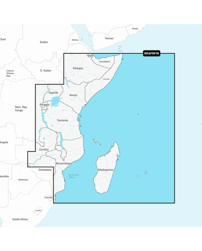
Garmin Navionics+ East Africa Marine Charts on MicroSD Card
Garmin Navionics+ East Africa Marine Charts on MicroSD Card
Area NSAF001R
Detailed coverage of the coast of East Africa from Southern Mozambique Border to Djibouti including Madagascar, Comores, Seychelles, Mauritius, Reunion & Lake Kariba
Garmin Navionics+ East Africa Marine Charts on MicroSD Card
Area NSAF001R
Detailed coverage of the coast of East Africa from Southern Mozambique Border to Djibouti including Madagascar, Comores, Seychelles, Mauritius, Reunion & Lake Kariba
IT’S A WHOLE NEW LOOK ON YOUR CHARTPLOTTER
Featuring vibrant colours, a streamlined interface and combined coastal/inland content with a popular Navionics® style colour palette, Garmin Navionics+ cartography makes it easy to plot your course with the world’s No. 1 name in marine mapping1.
Navigate with our best offshore and inland lake coverage for your Garmin chartplotter.
See it your way. Customise your view with various chart layers and overlay combinations.
With your included one-year subscription, access daily updates via the ActiveCaptain® smart device app.
Auto Guidance+™ technology2 lets you navigate with suggested dock-to-dock routings.
Select up to 10 colour-shaded target depth ranges to scope out the best fishing spots.
Save money by renewing your subscription — and continue accessing daily updates plus new content downloads.

Feature List
| Navionics+ | Navionics+ Vision | |
|---|---|---|
| Coastal Content | • | • |
| Inland Content | 44,000+ lakes | 44,000+ lakes |
| Detailed Nautical Charts | • | • |
| SonarChart HD Bathymetry1 | • | • |
| Daily Updates1 | • | • |
| Dock-to-dock Route Guidance Technology1,2 | • | • |
| Plotter Sync1 | • | • |
| Community Edits | • | • |
| Advanced Map Options1 | • | • |
| SonarChart Live Mapping | • | • |
| High-resolution Relief Shading1 | Via Chart Installer | |
| Satellite Imagery1 | Via Chart Installer | |
| Sonar Imagery1 | Via Chart Installer | |
| Aerial Photography | • | |
| 3D View1 | • |
Compatable Garmin Devices
| ECHOMAP™ CHARTPLOTTERS | BlueChart compatible | Garmin Navionics+ compatible |
|---|---|---|
| ECHOMAP (NON CHIRP) | ✓ | |
| ECHOMAP CHIRP (4/5/7/9) | ✓ | |
| ECHOMAP PLUS (4/6/7/9) | ✓ | |
| ECHOMAP UHD (6) | ✓ | |
| ECHOMAP UHD (7/9) | ✓ | ✓ |
| ECHOMAP UHD2 (5/7) | ✓ | |
| ECHOMAP UHD2 (6/7/9) | ✓ | |
| ECHOMAP ULTRA (10/12) | ✓ |
| GPSMAP® CHARTPLOTTERS | BlueChart compatible | Garmin Navionics+ compatible |
|---|---|---|
| GPSMAP 4000/5000/6000/7000 | ✓ | |
| GPSMAP 7X1/5X7 | ✓ | |
| GPSMAP 8X0/10X0 | ✓ | |
| GPSMAP 7X2/9X2 | ✓ | |
| GPSMAP 10X2/12X2 | ✓ | |
| GPSMAP 12X2 TOUCH | ✓ | ✓ |
| GPSMAP A12 | ✓ | ✓ |
| GPSMAP A7 | ✓ | ✓ |
| GPSMAP 7X21/9X21/12X2 PLUS | ✓ | ✓ |
| GPSMAP 7X3/9X3/12X3 | ✓ | |
| GPSMAP 7400/7600 | ✓ | |
| GPSMAP 8000 | ✓ | |
| GPSMAP 8400/8600 | ✓ | |
| GPSMAP 8500 BB | ✓ | |
| GPSMAP 8700 BB | ✓ | ✓ |
| OEM | BlueChart compatible | Garmin Navionics+ compatible |
|---|---|---|
| YAMAHA CL7 | ✓ | |
| GPSMAP A12 - VOLVO | ✓ | ✓ |
| GPSMAP 7X3/9X3/12X3 - VOLVO | ✓ | |
| GPSMAP 8000 - VOLVO | ✓ | |
| GPSMAP 7400/7600 - VOLVO | ✓ | |
| GPSMAP 8400/8600 - VOLVO | ✓ |
| HANDHELDS AND WEARABLES | BlueChart compatible | Garmin Navionics+ compatible |
|---|---|---|
| GPSMAP 78/78S/78SC | ✓ | |
| GPSMAP 79 | ✓ | |
| GPSMAP 86X/86SC/86i | ✓ | |
| GPSMAP 276 | ✓ | |
| QUATIX 6 | ✓ | |
| QUATIX 7 | ✓ |
| CARD READERS | BlueChart compatible | Garmin Navionics+ compatible |
|---|---|---|
| Garmin Card Reader1 | ✓ | ✓ |
| USB Card Reader | ✓ | ✓ |
Reviews
No customer reviews for the moment.
You need to be logged in or create an account to give your appreciation of a review.


