


There are no more items in your cart


Garmin BlueChart g3 Africa Southern Coastal and Inland Charts HXAF002R on microSD /SD
R3,799.00
R3,514.08
Tax included
Garmin BlueChart g3 Africa
Southern Coastal and Inland Charts
HXAF002R
on microSD™/SD™
Detailed coverage of the coast of Southern Africa and it's major inland lakes and Waterways.... Namibe, Ang. to Angoche Island, Moz. Tristan da Cunha Islands, St. Helena Island and the Prince Edward Islands.
Garmin BlueChart g3 Africa
Southern Coastal and Inland Charts
HXAF002R
on microSD™/SD™
Detailed coverage of the coast of Southern Africa and it's major inland lakes and Waterways.... Namibe, Ang. to Angoche Island, Moz. Tristan da Cunha Islands, St. Helena Island and the Prince Edward Islands.
Coverage
Detailed coverage of the coast of southern Africa and it's major lakes. Coverage is from Namibe, Ang. to Angoche Island, Moz. including the ports of Cape Town, Durban and Port Elizabeth, SA and Maputo, Moz. Coverage also includes Lakes Kariba, Cahora Bassa, the Vanderkloof and Gariep Dams, the Bloemhof Dam/Vaal River/Vaal Dam system, the Tristan da Cunha Islands, the island of St. Helena and the Prince Edward Islands. Also includes Relief Shading for a select number of dams, such as Loskop, Arabie, Vaal River, Witbank, Roodekoppies, Midmar, Nandoni, Spienkop, Albert Falls, Inanda, and more.
Our Advanced Chart Offering
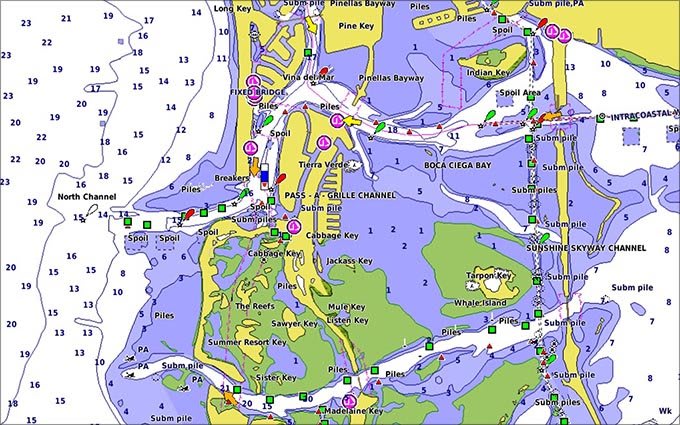
- Derived from official charts and private sources to provide navigational aids, spot soundings, depth contours, tides and currents, and detailed harbors and marinas
- Depth Range Shading for up to 10 depth ranges enables you to view your target depth at a glance
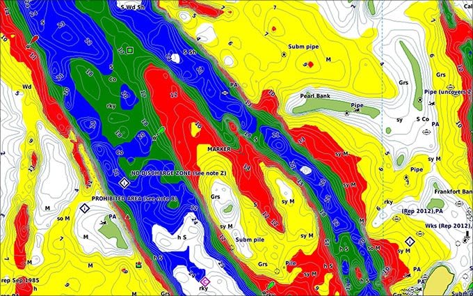
- Up to 1-foot contours provide a more accurate depiction of the bottom structure for improved fishing charts and navigation in swamps, canals and marinas
- Shallow Water Shading feature allows for depth shading at a user-defined level to aid in navigation
- Worldwide coverage available
- Keep your charts up to date with our industry-leading New Chart Guarantee and discount card update program
Advanced Chart Detail
Detailed charts help the mariner guide their boat in and out of port with confidence.

Depth Range Shading
Displays high-resolution Depth Range Shading for up to 10 depth ranges so you can view your designated target depth.
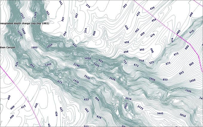
Detailed Contours
BlueChart g3 HD features 1-foot contours that provide a more accurate depiction of bottom structure for improved fishing charts and enhanced detail in swamps, canals and port plans.
BlueChart Feature Comparison
| Feature | g2 HD | g2 Vision HD |
|---|---|---|
| 1' HD Contours | • | • |
| Depth Range Shading | • | • |
| Shallow Water Shading | • | • |
| Navigational aids, spot soundings, depth contours, tides and currents and detailed harbors and marinas | • | • |
| Auto Guidance | • | |
| 3-D Views (MarinerEye & FishEye) | • | |
| High Resolution Satellite Imagery | • | |
| Aerial Photography | • | |
| Detailed coastal roads up to 5 miles inland | • |
Compatable Garmin Devices
| ECHOMAP™ CHARTPLOTTERS | BlueChart compatible | Garmin Navionics+ compatible |
|---|---|---|
| ECHOMAP (NON CHIRP) | ✓ | |
| ECHOMAP CHIRP (4/5/7/9) | ✓ | |
| ECHOMAP PLUS (4/6/7/9) | ✓ | |
| ECHOMAP UHD (6) | ✓ | |
| ECHOMAP UHD (7/9) | ✓ | ✓ |
| ECHOMAP UHD2 (5/7) | ✓ | |
| ECHOMAP UHD2 (6/7/9) | ✓ | |
| ECHOMAP ULTRA (10/12) | ✓ |
| GPSMAP® CHARTPLOTTERS | BlueChart compatible | Garmin Navionics+ compatible |
|---|---|---|
| GPSMAP 4000/5000/6000/7000 | ✓ | |
| GPSMAP 7X1/5X7 | ✓ | |
| GPSMAP 8X0/10X0 | ✓ | |
| GPSMAP 7X2/9X2 | ✓ | |
| GPSMAP 10X2/12X2 | ✓ | |
| GPSMAP 12X2 TOUCH | ✓ | ✓ |
| GPSMAP A12 | ✓ | ✓ |
| GPSMAP A7 | ✓ | ✓ |
| GPSMAP 7X21/9X21/12X2 PLUS | ✓ | ✓ |
| GPSMAP 7X3/9X3/12X3 | ✓ | |
| GPSMAP 7400/7600 | ✓ | |
| GPSMAP 8000 | ✓ | |
| GPSMAP 8400/8600 | ✓ | |
| GPSMAP 8500 BB | ✓ | |
| GPSMAP 8700 BB | ✓ | ✓ |
| OEM | BlueChart compatible | Garmin Navionics+ compatible |
|---|---|---|
| YAMAHA CL7 | ✓ | |
| GPSMAP A12 - VOLVO | ✓ | ✓ |
| GPSMAP 7X3/9X3/12X3 - VOLVO | ✓ | |
| GPSMAP 8000 - VOLVO | ✓ | |
| GPSMAP 7400/7600 - VOLVO | ✓ | |
| GPSMAP 8400/8600 - VOLVO | ✓ |
| HANDHELDS AND WEARABLES | BlueChart compatible | Garmin Navionics+ compatible |
|---|---|---|
| GPSMAP 78/78S/78SC | ✓ | |
| GPSMAP 79 | ✓ | |
| GPSMAP 86X/86SC/86i | ✓ | |
| GPSMAP 276 | ✓ | |
| QUATIX 6 | ✓ | |
| QUATIX 7 | ✓ |
| CARD READERS | BlueChart compatible | Garmin Navionics+ compatible |
|---|---|---|
| Garmin Card Reader1 | ✓ | ✓ |
| USB Card Reader | ✓ | ✓ |
Reviews
No customer reviews for the moment.
You need to be logged in or create an account to give your appreciation of a review.