 Small Chart) NAAF002R")
 NAAF001R")


There are no more items in your cart


Navionics Platinum + Africa and Middle East Commores Mauritius and Seychelles Large Chart Area NAAF30L
R7,850.00
R7,457.50
Tax included
NAVIONICS Platinum + "LARGE CHART"
AFRICA, MIDDLE EAST, INDIAN OCEAN ISLANDS and St HELENA
AREA NAAF630L
Includes 1st Year Navionics Subscription
NAVIONICS Platinum + "LARGE CHART"
AFRICA, MIDDLE EAST, INDIAN OCEAN ISLANDS and St HELENA
AREA NAAF630L
Coastal coverage of the coast of Africa from Tripoli, Libya thru the Red Sea and around the Cape to Dakar, Senegal including the Suez Canal and the Levant, the coast of the Arabian Peninsula, the Persian Gulf, Madagascar, Socotra, Zanzibar, Reunion, Mauritius, the Seychelles, the Comoros, the Prince Edward Islands, Tristan de Cunha, St Helena Island, Ascension Island, the Cape Verde Islands, Malta and Cyprus. Coverage of ports such as Alexandria, Egypt; Djibouti; Manama, Bahrain; Dubai; Cape Town, South Africa and Lagos, Nigeria are included.
Media: Micro SD Card and Adaptor
Includes 1st Year Navionics Subscription
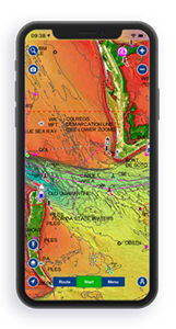
CLICK HERE TO VIEW CHART ON NAVIONICS CHART VIEWER
PLATINUM+ CARTOGRAPHY
Navionics Platinum+™ charts include all the content of Navionics®+ cartography, with integrated offshore and inland mapping, 44,000+ lakes and additional viewing options for relief shading, satellite imagery with SonarChart shading overlay, 3D perspective view, aerial photos and more.
______________________________________________________________________________________________________________________________________________________________
THE NAVIONICS SUBSCRIPTION
A one-year subscription to Daily Updates and advanced features is included when you purchase any new Navionics Platinum+ mapping solution. After a year, you can renew at a discounted price.
CHARTS AND UPDATES
Nautical Chart – Comprehensive charts are derived from multiple official, government and private sources, displayed in a familiar look and feel
SonarChart HD Bathymetry – Innovative 1' (0.5 m) bathymetry charts are created by using Navionics proprietary systems that augment existing content with sonar data contributed by the boating community
Community Edits – Get useful local knowledge from edits made by users of the Navionics Boating app on your compatible smart device.
Daily Updates – Up to 5,000 daily updates to our charts give you the most accurate, most current Navionics data available.
ADVANCED FEATURES
Dock-to-dock Route Guidance – Start your trip with a suggested path.
SonarChart Live Mapping Feature – Watch new HD depth maps develop in real time as your boat moves through the water.
Advanced Map Options – Customize your view to focus on the details that matter most
Plotter Sync – Transfer routes and markers, update chart layers and more — between your compatible chartplotter and the Navionics Boating app.
OVERLAYS
Relief Shading – Get an easy-to-interpret, clearer view of bottom structure. Check coverage.
Satellite Imagery with SonarChart Shading Overlay – Experience an enhanced awareness above and below the waterline. Check coverage.
PLATINUM+ ADDITIONAL VIEWING OPTIONS
3D View – Adjust the perspective of your chart view to highlight key features and enhance awareness
Aerial Photos – Get a better sense of your surroundings.
COVERAGE AREAS
Worldwide map coverage is available, with integrated content making it easier to select the navigation features and map regions you want. Choose from large coverage areas (Large) to more localized chart cuts (Regular).
COMPATIBILITY
Check compatibility of Platinum+ content and features with your GPS chartplotter.
1 Subscription required.
2 Dock-to-dock Route Guidance is for planning purposes only and does not replace safe navigation operations.
3 Subscription not required for SonarChart Live mapping feature on some chartplotter models; requires latest chartplotter firmware release.
NOTE: Navionics+ and Platinum+ cards are not compatible with Garmin chartplotters.
Daily updates and advanced features are included for one year.
Enables SonarChart Live on Seleted Lowrance, Simrad and B&G Chartplotter Combos:
Cartography Subscription Solutions for Navionics-compatible Chartplotter Brands
| Navionics+ | Platinum+ | |
|---|---|---|
| Coastal Content | • | • |
| Inland Content | SOME - REFER CHART VIEWER | SOME - REFER CHART VIEWER |
| Detailed Nautical Charts | • | • |
| Daily Updates1 | • | • |
| Dock-to-dock Route Guidance 1,2 | • | • |
| Plotter Sync1 | • | • |
| Community Edits | • | • |
| Advanced Map Options1 | • | • |
| SonarChartTM Live Mapping3 | • | • |
| Relief Shading1 | Via Chart Installer | |
| Satellite Imagery with SonarChartTM Shading Overlay1 | Via Chart Installer | |
| Aerial Photography | • | |
| 3D View | • |
Reviews
No customer reviews for the moment.
You need to be logged in or create an account to give your appreciation of a review.