
")


There are no more items in your cart


Garmin GPSMAP 1022 - World Basemap Chartplotter MFD
R41,599.00
R36,498.00
Tax included
Garmin GPSMAP 1022 - World Basemap Chartplotter MFD
Includes Wordwide Base Map (No Internal Sonar Module).
Supports Panoptix and Black Box Sonar Modules.
- GPSMAP 1022 chartplotter
- Power/data cable
- NMEA 2000 T-connector
- NMEA 2000 drop cable (2 m)
- Bail mount kit with knobs
- Flush mount kit with gasket
- Protective cover
- Trim piece snap covers
- Documentation
Garmin GPSMAP 1022 - World Basemap Chartplotter MFD
Available from 28 May 2026
Includes Wordwide Base Map (No Internal Sonar Module).
Supports Panoptix and Black Box Sonar Modules.
GPSMAP 1022 is designed for cruisers, sailors and sailing racers who need the advanced all-in-one solution provided by our 12-inch keyed chartplotter.
CLICK HERE TO DOWNLOAD GARMIN MARINE PRODUCT COMPARISON CHART
- GPSMAP 1022 chartplotter
- Power/data cable
- NMEA 2000 T-connector
- NMEA 2000 drop cable (2 m)
- Bail mount kit with knobs
- Flush mount kit with gasket
- Protective cover
- Trim piece snap covers
- Documentation
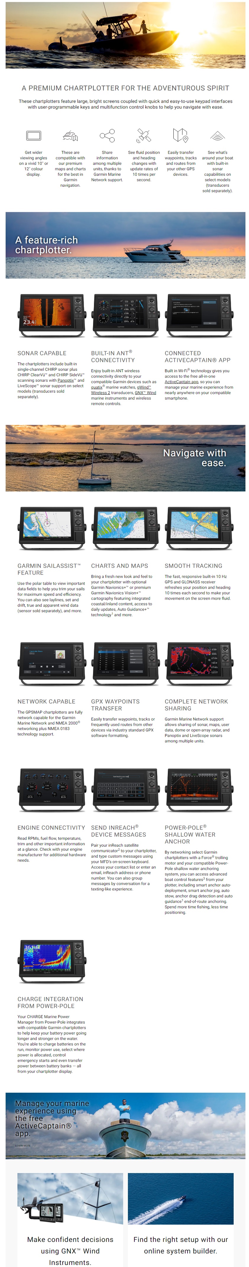
10-inch Chartplotter Is An All-in-One Solution
- 10-inch colour display with keypad interface and multifunction control knob
- High-sensitivity internal 10 Hz GPS and GLONASS receiver
- Fully network capable for Garmin Marine Network and NMEA 2000® plus NMEA 0183 support
- Supports optional BlueChart® g2 Vision® HD charts for Auto Guidance and other premium navigation features
GPSMAP 1022 is designed for cruisers, sailors and sailing racers who need the advanced all-in-one solution provided by our 10-inch keyed chartplotter.
Features a large, bright screen coupled with a quick and easy-to-use keypad interface with user-programmable keys and a multifunction control knob.
Complete Network Sharing
Garmin Marine Network support allows sharing of sonar, maps, user data, dome or open-array radar, IP cameras and Panoptix™ sonar among multiple units. Includes NMEA 2000 network connectivity and NMEA 0183 support for autopilots, digital switching, FUSION-Link, VHF, AIS and other sensors.
Built-in ANT® Connectivity
Enjoy built-in ANT wireless connectivity directly to quatix® marine watch, Garmin Nautix™ in-view display, gWind™ Wireless 2 transducer, GNX™ Wind marine instrument and wireless remote controls.
Heading, Position Refreshed 10 Times per Second
Fast, responsive built-in 10 Hz GPS and GLONASS receiver refreshes your position and heading 10 times each second to make your movement on the screen more fluid. It makes dropping up to 5,000 accurate waypoints — and finding your way back to them — quick and easy.
Upgrade to Our Best Maps on the Water
Two SD™ card slots provide expandable memory for accessory map purchases, such as BlueChart® g2 HD or BlueChart® g2 Vision® HD, which adds Garmin patented Auto Guidance¹ and other great features.
Built-in SailAssist Features
To help you gain a wind-maximising competitive edge, your chartplotter features a pre-race guidance page that shows your virtual starting line along with data fields showing laylines, time to burn before the start and a race timer that can be synchronised across all your networked Garmin GPS products. In addition, other supported sailing features include an enhanced wind rose, heading and course-over-ground lines, set and drift, true and apparent wind data and more.
GPX Waypoints Transfer
If you have waypoints, tracks or frequently used routes stored on another manufacturer’s GPS product — or on a Garmin handheld device — it’s easy to transfer those items to your new Garmin chartplotter via industry-standard GPX software formatting.
The Ultimate Connected Boating App
The free all-in-one ActiveCaptain™ app allows you to manage your marine experience from nearly anywhere. It creates a simple yet powerful connection between your compatible mobile device and your Garmin chartplotter, charts, maps and the boating community. Wherever you are, you’ll have unlimited access to your cartography, the ability to purchase new maps and charts and access to the Garmin Quickdraw™ Contours Community. Stay connected with smart notifications on your chartplotter screen. You can also plan a trip or pre-fish a lake, and ActiveCaptain will automatically sync with your chartplotter. Even get notifications for software updates, and decide when to download them on your device.
¹Auto Guidance is for planning purposes only and does not replace safe navigation operations.
iPhone and iPad are trademarks of Apple Inc., registered in the U.S. and other countries. App Store is a service mark of Apple Inc. Wi-Fi is a registered trademark of the Wi-Fi Alliance.
General |
|
| DIMENSION | 31.8 x 18.5 x 6.9 cm |
|---|---|
| TOUCHSCREEN | |
| DISPLAY SIZE |
22.4 x 12.5 cm; 10.1" (25.7 cm) diagonal |
| DISPLAY RESOLUTION | 1024 x 600 pixels |
| DISPLAY TYPE | WSVGA display |
| WEIGHT |
1.85 kg |
| WATER RATING |
IPX7 |
| MOUNTING OPTIONS | Bail or flush |
Sensors |
|
| BUILT-IN RECEIVER HZ | 10 Hz high-sensitivity |
|---|---|
| NMEA 2000® COMPATIBLE | Yes |
| NMEA 0183 COMPATIBLE | Yes |
Maps & memory |
|
| CARD SLOTS | 2 SD™ cards |
|---|---|
| WAYPOINTS | 5,000 |
| ROUTES | 100 |
Chartplotter features |
|
| GARMIN SMARTMODE COMPATIBLE (CUSTOMISABLE MONITOR PRESETS) | Yes |
|---|---|
| SUPPORTS AIS (TRACKS TARGET SHIPS POSITION) | Yes |
| SUPPORTS DSC (DISPLAYS POSITION DATA FROM DSC-CAPABLE VHF RADIO) | Yes |
| SUPPORTS FUSION-LINK™ COMPATIBLE RADIOS | Yes |
| GSD™ BLACK BOX SONAR SUPPORT | Yes |
| GCV™ BLACK BOX SONAR SUPPORT | Yes |
| ACTIVECAPTAIN COMPATIBLE | Yes |
| PANOPTIX SONAR SUPPORT | Yes |
| FORCE TROLLING MOTOR SUPPORT | Yes |
| GRID™ (GARMIN REMOTE INPUT DEVICE) COMPATIBLE | Yes |
| WIRELESS REMOTE COMPATIBLE | Yes |
Connections |
|
| NMEA 0183 INPUT (RX) PORTS |
1 |
|---|---|
| VIDEO INPUT PORTS |
1 BNC |
| VIDEO OUTPUT PORTS | None |
| GARMIN MARINE NETWORK™ PORTS |
2 |
Electrical Features |
|
| POWER INPUT | 10 to 32 Vdc |
|---|---|
| TYPICAL CURRENT DRAW AT 12 VDC | 1.9 A |
| MAXIMUM CURRENT DRAW AT 12 VDC | 2.7 A |
| MAXIMUM POWER USAGE AT 10 VDC | 32.4W |
- Compact Reactor™ 40 Hydraulic Autopilot Starter Pack
- Compact Reactor™ 40 Hydraulic Autopilot with GHC™ 20 and Shadow Drive™ Pack
- Compact Reactor™ 40 Hydraulic Autopilot with GHC™ 20 Corepack
- Garmin AIS™ 300 Blackbox Receiver
- GLS™ 10 Sonar Module
- GMR™ 1224 xHD2
- GMR™ 1226 xHD2GR™ 18 HD+
- GMR™ 18 HD
- GMR™ 18 xHD
- GMR™ 24 HD RadoGMR™ 24 xHD
- GMR™ 2524 xHD2
- GMR™ 2526 xHD2GMR™ 424 xHD2
- GMR™ 606 xHD Open Array Radar and Pedestal
- GMR™ 624 xHD2GMR™ 626 xHD2
- GMR Fantom™ 124
- GMR Fantom™ 126
- GMR Fantom™ 18
- GMR Fantom™ 24
- GMR Fantom 254
- GMR Fantom 256
- GMR Fantom™ 4
- GMR Fantom™ 54
- GMR Fantom™ 56
- GMR Fantom™ 6
- GSD™ 24 Advanced Sonar Module
- GSD™ 25 Premium Sonar Module
- GSD™ 26 CHIRP Professional Sonar Module
- Meteor™ 300 Audio System
- OnDeck™ Hub
- Panoptix LiveScope™ System
- Panoptix™ PS22-TR
- Panoptix™ PS30
- Panoptix™ PS31Panoptix™ PS51-TH
- Panoptix™ PS60 Thru-hull Down Transducer
- Reactor™ 40 Hydraulic Autopilot
- Reactor™ 40 Hydraulic Corepack with SmartPump
- Reactor™ 40 Mechanical/Retrofit/Solenoid Corepack
- Reactor™ 40 Mechanical/Retrofit/Solenoid Corepack
- Reactor™ 40 Steer-by-wire Corepack for Volvo-Penta®Reactor™ 40 Steer-by-wire Corepack for Yamaha® Helm Master™
- Reactor™ 40 Steer-by-wire Standard Corepack
- VHF 100 Marine Radio
- VIRB® 360
- Garmin Force Trolling Motor
Reviews
No customer reviews for the moment.
You need to be logged in or create an account to give your appreciation of a review.