

Cart
0
Product
Products
(empty)
No products
R0.00
Shipping
R0.00
Tax
R0.00
Total
Prices are tax included
Product successfully added to your shopping cart
Quantity
Total
There are 0 items in your cart. There is 1 item in your cart.
Total products
(tax incl.)
Total shipping (tax incl.)
R0.00
Tax
R0.00
Total
(tax incl.)


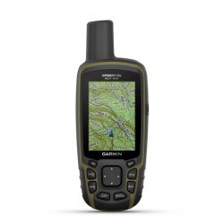
Garmin GPSMAP 65s Handheld GPS - Worldwide Basemap
010-02451-01
New
Garmin GPSMAP 65s Handheld GPS
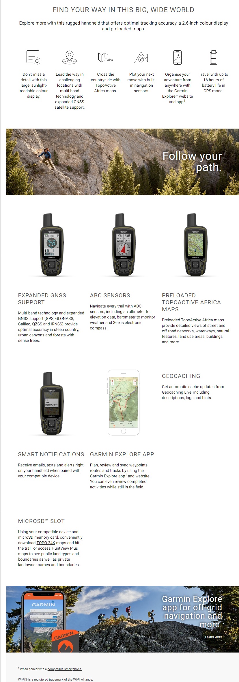
FIND YOUR WAY IN THIS BIG, WIDE WORLD
Explore more with this rugged handheld that offers optimal tracking accuracy, a 2.6-inch colour display and preloaded maps.
With Altimeter & Compass
- USB cable
- Carabiner clip
- Documentation
In Stock at Local Warehouse. Allow 3 Days for us to Recieve
More info
Garmin GPSMAP 65s Handheld GPS
FIND YOUR WAY IN THIS BIG, WIDE WORLD
Explore more with this rugged handheld that offers optimal tracking accuracy, a 2.6-inch colour display and preloaded maps.
With Altimeter & Compass
- USB cable
- Carabiner clip
- Documentation
Physical & Performance
| Display Size | 3.6 x 5.5 cm; 2.6-inch diagonal (6.6 cm) |
| Battery type | 2 AA batteries (not included); NiMH or Lithium recommended |
| Display Resolution | 160 x 240 pixels |
| GPS | Yes |
| Dimension | 6.1 x 16.0 x 3.6 cm |
| Interface | High-speed mini USB and NMEA 0183 compatible |
| Waterproof | IPX7 |
| Weight | 217 g with batteries |
| Display Type | Transflective, 65K colour TFT |
| Battery life | 16 hours |
| High-sensitivity receiver | Yes |
Maps & Navigation
| Storage and Power Capacity | Yes (32 GB max microSD™ card) |
| Waypoints/favourites/locations | 5,000 |
| Preloaded maps |
Yes (TopoActive Africa) |
| Basemap | Yes |
| Navigation Routes | 200, 250 points per route; 50 points auto routing |
| Navigation Track Log | 10,000 points, 200 saved tracks |
| Memory/history | 16 GB (user space varies based on included mapping) |
| Ability to add maps | Yes |
Features
| Send route selection to MapShare during trip | No |
| QZSS | Yes |
| Satellite Imagery | 250 BirdsEye Imagery files |
| Send waypoints to MapShare during trip | No |
| Active Weather | No |
| Contacts | No |
| Rinex logging | No |
| inReach remote widget | No |
| Compatible with Garmin Connect™ Mobile | Yes |
| Touchscreen | No |
| LED beacon flashlight | No |
| inReach remote compatible | No |
| Sun and moon information | Yes |
| Virtual keyboard for custom messaging | No |
| MapShare compatible with tracking | No |
| IRNSS | No |
| Geocaching-friendly | Yes (paperless) |
| Send and receive text messages to other inReach device | No |
| GLONASS | Yes |
| Send and receive text messages to SMS and email | No |
| Frequency band | No |
| Displays national, state and local parks, forests, and wilderness areas | Yes |
| Smart notifications on handheld | Yes |
| Connect IQ™ (downloadable watch faces, data fields, widgets and apps) | No |
| Custom maps compatible | Yes (500 custom map tiles) |
| Compatible with Earthmate | No |
| Dog tracking | No |
| Connections Wireless Connectivity | Yes - Bluetooth®, ANT+® |
| LiveTrack | No |
| Exchange locations with other inReach device | No |
| Vibration alert | No |
| Map segments | 3,000 |
| Point-to-point navigation | Yes |
| Picture viewer | Yes |
| Barometric altimeter | Yes |
| Weather forecasts | No |
| XERO™ Locations | No |
| Interactive SOS | No |
| VOX (voice activation) | No |
| Automatic routing (turn by turn routing on roads) for outdoor activities | Yes |
| GPS compass (while moving) | Yes |
| Includes detailed hydrographic features (coastlines, lake/river shorelines, wetlands and perennial and seasonal streams) | Yes |
| Multi-band frequency | Yes |
| Includes searchable points of interests (parks, campgrounds, scenic lookouts and picnic sites) | Yes |
| FISH FORECAST | Yes |
| Compass | Yes (tilt-compensated 3-axis) |
| Lens material |
chemically strengthened glass |
| Compatible with Garmin Explore™ app | Yes |
| Tracks | 200 |
| Galileo | Yes |
| Garmin Explore website compatible | Yes |
| Area calculation | Yes |
| MIL-STD-810 | No |
| Location reporting (send and receive GPS positions) | No |
| VIRB® camera remote | Yes |